


Virginia Flood Resilience Initiative
In 2020, state legislation passed that allocated significant funds to help regions and localities across Virginia reduce the harmful effects of flooding. In recent decades, damage due to flooding has worsened for many communities throughout Virginia; however, many communities do not have the time or resources to devote to flood resilience.
The Virginia Community Flood Preparedness Fund (VCFPF) helps communities assess their vulnerability to flood events and develop and implement actionable flood resilience plans, studies, and projects. A portion of the state fund was set aside for projects in low-income geographic areas. The Weldon Cooper Center created a flood resilience team to help Virginia localities and Planning District Commissions (PDCs) secure a Virginia Community Flood Preparedness Fund grant and build their capacity for developing effective flood management plans. The interdisciplinary team of researchers, staff, and students from the School of Engineering and Applied Science, the School of Architecture, the Institute for Engagement and Negotiation, and UVA-Wise was led by project manager Elizabeth Marshall from the Cooper Center.
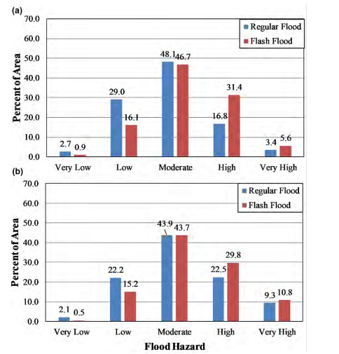
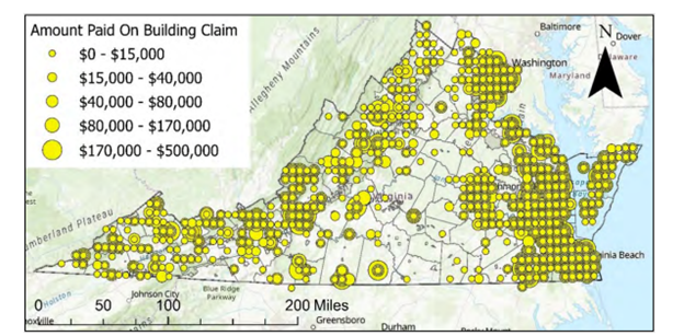
In spring 2023, the team released a report to help inland areas determine their preparedness to plan for flood resilience, featuring a flood hazard dashboard that helps communities assess flood risk. One key deliverable of the project is a flood hazard inventory. Using geospatial mapping and data-driven techniques, the inventory provides a region-wide, high-resolution flood hazard analysis for both riverine floods and flash floods. Another priority was the localities’ desire to ensure future planning reflects the experience of the districts’ entire constituency. Key factors for future planning include: funding, staffing, training and experience, adaptability, emergency readiness, and protecting natural resources and socially vulnerable populations.
The Flood Resilience Initiative aligns with the UVA 2030 Plan's emphasis on serving the Commonwealth of Virginia and the Cooper Center's mission of helping strengthen and support Virginia’s communities. In the words of Tom Raab, South Boston Town Manager, “By identifying the most vulnerable areas and creating strategies to mitigate risks, South Boston will be better prepared to help our residents, businesses, and infrastructure from potential damage and losses from flood events.”
For the full report, download the file below.